The Landsat Thematic Mapper (TM) and Enhanced Thematic Mapper Plus (ETM+) sensors capture reflected solar energy, convert these data to radiance, then rescale this data into an 8-bit digital number (DN) with a range between 0 and 255. It is possible to manually convert these DNs to ToA Reflectance using a two-step process. The first step is to convert the DNs to radiance values using the bias and gain values specific to the individual scene you are working with. The second step converts the radiance data to ToA reflectance.
The Landsat 8 OLI sensor is more sensitive so these data are rescaled into 16-bit DNs with a range from 0 and 65536. Also these data have been converted to reflectance, rather than radiance, so DNs can be manually converted to Reflectance in a single step.
ENVI can easily convert Landsat data from the USGS in the “USGS GeoTIFF with Metadata” format in a single step. This process is described in Section 1 of this document. For other Landsat data, or other remote sensing software, you may need to apply the manual conversion processes described in Section 2 or 3 below.
1. ENVI and USGS GeoTIFF with Metadata format data
The USGS now provides data in the GeoTIFF with Metadata format. ENVI software can easily convert the optical band data to ToA reflectance values when you open the USGS file that ends with “_MTL.TXT”. ENVI will automatically open the Landsat image as multiple files with the 6 or 7 bands of optical data as one of several files.
To create a reflectance data file using ENVI Classic, from the ENVI main menu bar select Basic Tools |Preprocessing |Calibration Utilities |Landsat Calibration. Select the optical data file (it has six or seven bands) and the ENVI Landsat Calibration dialog should open with all of the calibration parameters filled in. Click on the Reflectance radio button and enter an output file name.
For ENVI Standard, select from the Toolbox | Radiometric Correction | Radiometric Calibration. Select the optical data file and the Radiometric Calibration dialog opens. Under Calibration Type choose Reflectance and save the new file. As a reminder, reflectance values range from 0.0 to 1.0 and are stored in floating point data format.
2. Manually Converting Landsat 8 OLI data to ToA Reflectance:
These data can be converted to ToA Reflectance using rescaling factors and parameters found in the metadata file (MTL.txt) provided with the data. The formulas and detailed explanations can be found on the USGS site: Using the USGS Landsat 8 Product. You should use the formula that includes a correction for the sun angle.
3. Manually Converting Landsat TM and ETM data to ToA Reflectance:
This is a two-step process. First you must convert DNs to radiance values, then you need to convert these radiance values to reflectance values. For each scene you need to know the distance between the sun and earth in astronomical units, the day of the year (Julian date), and solar zenith angle. This information can also be found in Chapter 11 of the Landsat 7 Users Handbook . Sections of the Landsat 7 Users Handbook have been included in this document to guide you.
3.1. DN to Radiance
There are two formulas that can be used to convert DNs to radiance; the method you use depends on the scene calibration data available in the header file(s). One method uses the Gain and Bias (or Offset) values from the header file. The longer method uses the LMin and LMax spectral radiance scaling factors. Look for a file name such as LT5171034009024510.WO, or a file with .met or .txt as the file extension. For ETM+ images this information may be in a file name such as L71171035_03520000905_htm.fst.
Appropriate calibration parameter files are available on the Landsat Calibration page at the USGS.
3.1.1.Gain and Bias Method
The formula to convert DN to radiance using gain and bias values is:
![]()
Where:
Lλ is the cell value as radiance
DN is the cell value digital number
gain is the gain value for a specific band
bias is the bias value for a specific band
The ENVI formula in Band Math will look like:
0.05518 * (B1) + 1.2378
using a scene specific gain value of 0.05518 and an offset value of 1.2378. In the Band Pairing dialog you should match B1 with the appropriate optical band.
3.1.2.Spectral Radiance Scaling Method
The formula used in this process is as follows:
![]()
Where:
Lλ is the cell value as radiance
QCAL = digital number
LMINλ = spectral radiance scales to QCALMIN
LMAXλ = spectral radiance scales to QCALMAX
QCALMIN = the minimum quantized calibrated pixel value
(typically = 1)
QCALMAX = the maximum quantized calibrated pixel value
(typically = 255)
3.2. Radiance to ToA Reflectance
From the Landsat 7 Users Handbook – Chapter 11:
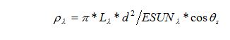
Where:
ρλ = Unitless plantary reflectance
Lλ= spectral radiance (from earlier step)
d = Earth-Sun distance in astronmoical units
ESUNλ = mean solar exoatmospheric irradiances
θs = solar zenith angle
The solar zenith angle can be calculated using the University of Oregon Solar Poistion Calulator.
The following tables are from the Landsat & Users Handbook – Chapter 11
http://landsathandbook.gsfc.nasa.gov/data_prod/prog_sect11_3.html
|
Band |
watts/(meter squared * μm) |
|---|---|
|
1 |
1969.000 |
|
2 |
1840.000 |
|
3 |
1551.000 |
|
4 |
1044.000 |
|
5 |
225.700 |
|
7 |
82.07 |
|
8 |
1368.000 |
|
Julian Day |
Distance |
Julian Day |
Distance |
Julian Day |
Distance |
Julian Day |
Distance |
Julian Day |
Distance |
|---|---|---|---|---|---|---|---|---|---|
|
1 |
.9832 |
74 |
.9945 |
152 |
1.0140 |
227 |
1.0128 |
305 |
.9925 |
|
15 |
.9836 |
91 |
.9993 |
166 |
1.0158 |
242 |
1.0092 |
319 |
.9892 |
|
32 |
.9853 |
106 |
1.0033 |
182 |
1.0167 |
258 |
1.0057 |
335 |
.9860 |
|
46 |
.9878 |
121 |
1.0076 |
196 |
1.0165 |
274 |
1.0011 |
349 |
.9843 |
|
60 |
.9909 |
135 |
1.0109 |
213 |
1.0149 |
288 |
.9972 |
365 |
.9833 |
.