ENVI can open and process most MODIS HDF data. However, the data formats and specific processing steps differ for daily scenes and the various domain products. Daily scenes have geographic coordinate information embedded in the file. Instructions for importing these data are covered in another FAQ. MODIS products are typically distributed using the sinusoidal projection in 10º tiles. Instructions for processing several types of data are described below.
MODIS Land Products
The MODIS Land product data are provided in HDF format using a sinusoidal projection. We recommend using the MODIS Conversion Tool Kit to import these data and reproject to Geographic Lat/Lon if desired as described in another YCEO FAQ.
You can open these directly in ENVI Standard from File | Open As | EOS | MODIS or from ENVI Classic File | Open External File | EOS | MODIS. Select the data layer(s) you wish to use and the new file will be in the sinusoidal projection. Methods for converting the data to the “geographic” projection vary by software version, as described below.
For ENVI Standard version 5.2 in the Toolbox select Raster Management | Reproject Raster. This opens the Reproject Raster dialog window. Browse to the input dataset, then select the Output Coordinate System (Geographic | World | WGS 1984) and finally enter an output filename and click OK.
For ENVI versions 5.1 and earlier you should use ENVI Classic to reproject these data. From the Classic main menu select Map | Convert Map Projection. Another alternative is to use an extension module to ENVI. We recommend using the MODIS Conversion Tool Kit to import these data. This is described in another YCEO FAQ.
MODIS Atmosphere Products
MODIS Atmosphere products are distributed in HDF format as are the Land products. ENVI Standard can open this dataset from File | Open As | EOS | MODIS but it only accesses the reflectance and coordinate files. To access the atmospheric products such as optical depth you are strongly encouraged to open these files using the MODIS Conversion Tool Kit described in another YCEO FAQ.
MODIS Ocean Products
MODIS Ocean products can be opened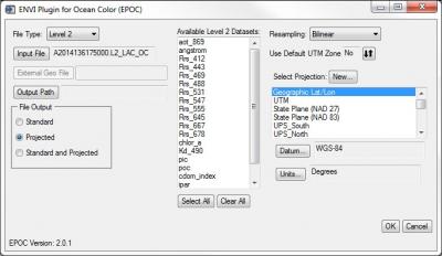 easily in ENVI Standard using the special extension EPOC found in the Toolbox under Extensions. Select the appropriate File Type (Processing Level 1, 2 or 3). Next select the input file and define the output location. For Level 2 or 3 products, choose the appropriate dataset(s) from the available list. Under File Output choose Projected and select the projection Geographic Lat/Lon and click OK to import the new file.
The ENVI Plugin for Ocean Color (EPOC) for ENVI was developed by Devin White. He has graciously made them publicly available on GitHub at: https://github.com/dawhite/ENVIPlugins
MODIS Snow and Ice Products
We recommend using the MODIS Conversion Tool Kit to import these data and reproject to geographic as described in another YCEO FAQ.
Alternatively, if you are using ENVI version 5.2 or above you can open these directly in ENVI Standard from File | Open As | EOS | MODIS or from ENVI Classic File | Open External File | EOS | MODIS. Select the data layer(s) you wish to use and the new file will be in the sinusoidal projection. To convert the data to the “geographic” projection, from the Toolbox select Raster Management | Reproject Raster. This opens the Reproject Raster dialog window. Browse to the input dataset, then select the Output Coordinate System (Geographic | World | WGS 1984) and finally enter an output filename and click OK.
If you are using ENVI version 5.1 or earlier, MODIS Snow and Ice products can be opened as generic HDF files in ENVI Standard from File | Open As | Generic | HDF4. However these files will have no projection or coordinate information.