There are many sites that you can use to locate and obtain Landsat satellite imagery. Two recommended sites are EarthExplorer and GLOVIS by the USGS. You will find a broad collection of Landsat data spanning the entire time of the program, beginning in the early 1970’s. The user interface and download processes are a bit different for each site. More information about each is listed below.
There are several international sources of Landsat images which typically charge $1,000 or more per scene. You may also find various government or non-profit organizations that maintain an archive of images for their region which can be shared with the public, or at least with research collaborators. Locating and accessing these sites is beyond the scope of this document.
Earth Explorer
The Earth Explorer site at: http://earthexplorer.usgs.gov/ includes many types of data in addition to Landsat images. Begin on the Search Criteria tab to define the location you are interested in. There are many ways to do this; click on the map to create a polygon, upload a shapefile, select a Landsat Path/Row, etc. While still on this tab define a time range and adjust the Result Options to determine how many images may be presented to you.
Next click on the Data Sets tab and expand the Landsat Archive section. You can select the Landsat sensor(s) you are interested in, or the Collection data and higher products as they become available You may need to modify the dates and/or the number of results to find appropriate data. (Note that there are many other types of data available on this site.)
Click on the Results tab to view images that meet your criteria. From this page you can look at browse images, inspect the meta data, display the footprint to see the scene coverage, download an image, or place an order. You must register on the site to access the images.
GLOVIS
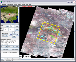 The USGS Global Visualization Viewer GLOVIS site at: http://glovis.usgs.gov/ has Landsat data, as well as ASTER and some MODIS satellite images. Select the appropriate image collection e.g. Landsat Archive | Landsat 4 – 5 TM and then navigate to the region you are interested in. You can use the Prev Scene and Next Scene buttons to scroll through the available images by date.
When you have located an image you wish to work with, click the Add button in the lower left to make it available for ordering. Users can select several images and place them in a “cart” for ordering. Most data are available for immediate download once they are “Added” to your cart. For these images, make sure you select the Level 1 Product. In other cases, the image request is submitted to the USGS and when the data are available the user will get an email with a link to retrieve the data. This may take a few hours to a few days.
Note: When you enter the site your browser must allow pop-up windows so that the Visualization Viewer window can open. Each user must register on this site before downloading or ordering images.