")
After a successful launch on Sept. 27, 2021, NASA and USGS have relesed the first images captured by their joint mission; Landsat 9.
The images were acquired on Oct. 31, 2021, and they are made public through this website. Landsat 9 carries two instruments: the Operational Land Imager 2, and the Thermal Infrared Sensor 2. These instruments are expected to allow scientist around the world to answer questions related to crop health, water quality, wildfire severity, and many more critical applications.
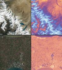
The USGS Acting Director, Dr. David Applegate, told NASA reporters that “The incredible first pictures from Landsat 9 satellite are a glimpse into the data that will help us make science-based decisions on key issues including water use, wildfire impact, coral reef degradation, glacier and ice-shelf retreat and tropical deforestation”. He also indicated that this joint mission will support the efforts to combat climate change and increase economic growth.
For more infomation about Landsat program please visit this website: https://www.nasa.gov/specials/landsat/