ASTER L1B full scenes and ASTER products (as of this writing) are delivered oriented along the satellite path. While these data are georeferenced, they are NOT oriented with north at the top of the image. These data should be rotated into a map orientation with north being at the top of the image. This step is NOT necessary for ASTER L1T full scenes.
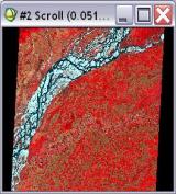
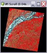
Below are two views of an ASTER dataset illustrating this issue. The left image is aligned to the along-track orientation, the angled path the satellite travels across the face of the earth. The right image has been rotated so north is up.
You should rotate these images to align them so north is up. Prior to performing this you need to check the data values of cells outside of the image, the black or white areas in the margins. This may be something like –NaN or 0 (zero). You will use this value as the background filler value in the next step.
From the Toolbox select Raster Management | Rotate / Flip Data. Accept the default Angle because ENVI extracts the correct rotation angle from the header information. Enter the margin value from above as the new Background value. Then enter a new filename and click OK to rotate the image so that North is Up.