Frequently Asked Questions - Sentinel 2
Sentinel 2 is part of the Copernicus earth observation program developed by the European Space Agency (ESA) to study the earth’s surface. The Sentinel 2 portion of the program consists of a pair of satellites that are designed to acquire reflected sunlight in the optical wavelengths. It is especially sensitive to variations in vegetation so is extremely useful for studying crops and forests.
Sentinel 2A was launched on 23 June 2015, the first image was acquired on 27 July 2015, and the program became operational on 15 October 2015. The satellite orbits the earth at an altitude of 786 km and has a swatch width of 290 km. This provides a return time of 10 days as compared with the 16-day return time of the Landsat program. Sentinel 2B was launched on 7 March 2017, it is positioned 180° from Sentinel 2A. Together, Sentinel 2A and 2B will provide near-global coverage every 5 days, with quicker return times at mid latitudes.
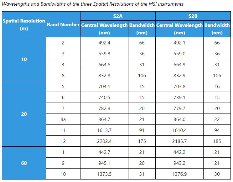
Data are acquired at three spatial resolutions and should be handled as separate files. There are four bands with a 10m spatial resolution. These are in the blue, green, red, and near infrared parts of the electromagnetic spectrum. The second file has six bands with 20m spatial resolution and the third file has three bands with 60m resolution. The wavelengths are described below. Note that four of the 20m bands are in the red edge and near infrared wavelengths.
From https://earth.esa.int/web/sentinel/missions/sentinel-2/instrument-payload/resolution-and-swath
Learn more about this program at:
the ESA Sentinel 2 website https://earth.esa.int/web/sentinel/missions/sentinel-2
and the USGS site: https://eros.usgs.gov/sentinel-2
You can obtain Sentinel 2 data from the ESA and from the USGS. Users must register for free access to data at either site. Currently ESA distributes Sentinel 2 data in entire swaths. These files are very large, sometimes 7+ GB when compressed. You can access these data directly from the ESA Copernicus Open Access hub at: https://scihub.copernicus.eu/ Users should read the online User Guide prior to searching for data.
Recommended Site:
The USGS distributes most of the Sentinel 2 data but has cut these data into much smaller tiles of 100 km X 100 km in the Level-1C top of atmosphere reflectance. These data are much easier to work with and users are encouraged to look for data here first. You can access these data at the USGS Earth Explorer site at: https://earthexplorer.usgs.gov/
You should begin your data search by first defining a small region of interest. You can expand this later as needed. You can enter a start and stop date to further limit your search. Next in the Data Sets tab scroll down and select Sentinel | Sentinel 2.
Click on the Results tab to display data that meets your search criteria. You can click on the Footprint icon to show the scene coverage. To the right of this is a Browse icon. This will display the image to help you decide if the scene meets your needs. Users are encouraged to only download one or two images initially. Once you gain experience working with these data you can come back and get more.
These instructions are for those using ENVI version 5.6.1.
Sentinel 2 data use very long folder and filenames that may cause problems in the Windows operating system. You should extract (unzip) the data into a folder near the top of the file structure. By this we mean U:\ rather than something like: U:\Project\Rasters\Sentinel\MyNewData\ImageDate. Once the data are extracted rename the new data folder to a shorter name. Sentinel 2 file name usually takes this fomat:
MMM_MSIXXX_YYYYMMDDHHMMSS_Nxxyy_ROOO_Txxxxx_<Product Discriminator>.SAFE
For example, a Sentinel data folder name might be:
S2A_MSIL1C_20211019T154251_N0301_R011_T18TXL_20211019T192902.SAFE
Which reflects the following infomration: an image obtained via Sentinel 2A (S2A), processed at Level L1C (MSIL1C), acquired on the 19th day of October of 2021 at 3:42:51 PM UTM (20211019T154251), processed with PDGS processing baseline 03.01 (N0301), Relative Orbit Number 011 (R011), Tile Number 18TXL (T18TXL), and its Product Discriminator is 20211019T192902. SAFE is the product format which stands for Standard Archive Format for Europe.
You can rename this file to something like: October19_2021.
To open the image, go the main ENVI menu and select File | Open As | Optical Sensors | European Space Agency | Sentinel 2. Navigate into the new folder and select the XML file. This, however, will be shorter filename such as:
MTD_MSIL2A.xml
ENVI should open the data into files based on spatial resolution. You can examine the data and save the file to ENVI format if you wish to use these data in the future. From the ENVI main menu select File | Save As | Save As… (ENVI, NITF, TIFF, DTED) and follow the instructions to save this file to a new folder structure for your project; it should not be placed in any of the original Sentinel folders. Consider including 10m or 20m as part of the filename to distinguish the resolution.
You can also open these data using the ESA Sentinel-2 Toolbox program SNAP. This is installed on the YCEO Lab systems. You can also download this software from the ESA site:
https://sentinel.esa.int/web/sentinel/toolboxes/sentinel-2
The ESA website has links to documentation and YouTube videos to instruct users. While you can view and manipulate these data quite easily in SNAP, it is a bit difficult to export these data into a format that can be used by ENVI. In order to export these data, they must all have a common spatial resolution. So if you want to use the four 10-meter bands you must resample the entire file to 10 meters. (this is a very large file!) You can then open this in ENVI and spectrally subset this to extract just the four bands of interest.