Frequently Asked Questions - VIIRS
The Visible Infrared Imaging Radiometer Suite (VIIRS) is an instrument onboard the Suomi National Polar-Orbiting Partnership (S-NPP) spacecraft, which was launched October 28, 2011. The VIIRS instrument follows the legacy of, and improves upon, the measurements made by the NOAA AVHRR and the MODIS instruments on Aqua and Terra. VIIRS observes Earth’s entire surface twice each day, with an equator crossing time of approximately 1:30 a.m. and 1:30 p.m. (local time). At an orbit of 835 km, VIIRS scans a swath that is approximately 3000 km wide, 710 km wider than MODIS, and wide enough to avoid gaps in coverage near the equator (unlike MODIS). The VIIRS instrument collects imagery of the land, atmosphere, oceans, and cryosphere across 22 spectral bands, ranging in wavelengths from 0.41 to 12.5 microns, and at two native spatial resolutions: 375m (I-bands) and 750m (M-bands).
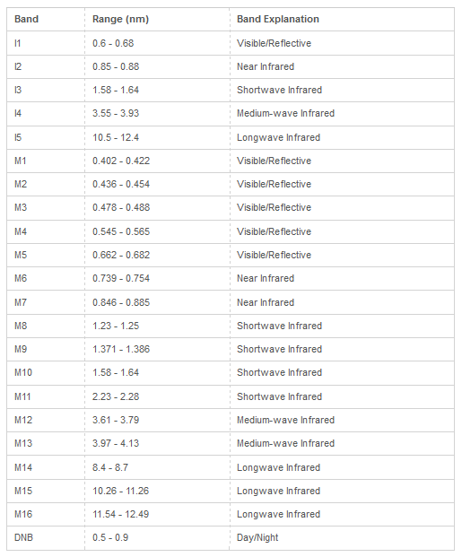
Table source: NASA/USGS LP DAAC
Land data: To allow consistency with MODIS, NASA resamples surface reflectance and other land products (vegetation indices, LAI/FPAR, thermal anomalies and fire) to 500 m, 1 km, and 0.05 degrees. These data are available as daily images, or 8-day to monthly composite images, and distributed as 1200 km x 1200 km tiles in a sinusoidal projection system. For more information, click here. Information for each NASA VIIRS land product can be found in the VIIRS Product Table.
The surface reflectance data are created by applying corrections for atmospheric gases and aerosols to the top of atmosphere reflectance data. Surface reflectance data are available from January 19, 2012 to present. Through LP DAAC, several surface reflectance products are available:
| Refectance product | temporal frequency | spatial resolution |
|---|---|---|
| VNP09GA | Daily | 500 m (I-bands), 1 km (M-bands) |
| VNP09A1 | 8-day composite | 1 km (M-bands) |
| VNP09H1 | 8-day composite | 500 m (I-bands) |
| VNP09CMG | Daily | 5600 m (0.05 degrees) |
In the VIIRS Product Table, you can click on each surface reflectance product to obtain more information and to find links to access the data.
NASA Earthdata Search provides access to surface reflectance data as well as the other NASA VIIRS products.
After creating an account and/or logging in, you may search for the product name (e.g. VNP09A1), as well as define your geographic area of interest and temporal range. The footprint of the VIIRS tile(s) that covers your area of interest will be shown on the map. You can then download some or all of the tiles that meet your criteria, or have them emailed to you.
For first-time users, it is recommended to watch Getting Started with VIIRS Surface Reflectance Data Part 1, which provides a step-by-step guide of finding and downloading VIIRS surface reflectance data from NASA Earthdata Search.